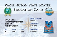
Reminder…Boaters in Washington need to have their Washington State Boater Education Card with them when operating a boat 15 horsepower or greater. Boat operators born before January 1,1955 are exempt but may choose to get a card if they plan to boat in Canada or Oregon, since both require mandatory education.
There are several ways to take the exam, but probably the most convenient is The BoatUS online course. It’s free and you can proceed at your own pace and winter is a good time to get this taken care of.
Dinghy hint….take a copy of your card, along with your Registration and whistle and put in an empty spice container to have onboard.